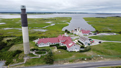
Camel City Drones provides a wide range of services tailored to real estate and development. From general land evaluations to an MLS ready portfolio, these services are guaranteed to help your property stand out amongst the rest.
Residential Imagery
Capture stunning aerial photos and videos that showcase a property from a unique perspective. Highlight property features, lot size, and surrounding areas that attract buyers, partners, and investors alike.
Inspections
See the unseen with safety and efficiency as a priority. Our services provide quality imagery allowing for advantaged views of hard to reach places such as roofs and gutters, siding, HVAC systems, and much more.
Land & Property Assessment
Gain valuable insights with detailed aerial imagery for land area evaluations. Assess terrain, property boundaries, and surrounding area to aid in planning, development, and investment decisions.
Packages built for you!

The Groundwork Package
From $125
Foundation-first photography for smaller listings.
-
Interior and exterior ground-level photography
-
15-20 high-resolution images
-
MLS-ready editing
-
Ideal for agents needing clean, consistent ground images

The Aerial Advantage
From $175
Elevate your listing with a sky-high perspective.
-
10-15 stunning drone images from multiple perspectives & angles
-
Color-enhanced and MLS-optimized
-
Great for showing off property size, layout, or scenery.

The Total View Package
From $250
Comprehensive coverage from top to bottom.
-
Ground & aerial combo for the upmost coverage
-
25-35 total professionally edited images
-
Best for full listings in need of full attention
Why visuals matter in real estate.
Listings with aerial photos sell up to 68% faster, and those featuring video receive over 400% more inquiries than those without! Professional visuals don’t just look great — they move properties faster and attract serious buyers.
Our Favorites

Real Estate
Real Estate


Project 12242 Highlight

DJI_0746 - Trim


